

#Short Answer
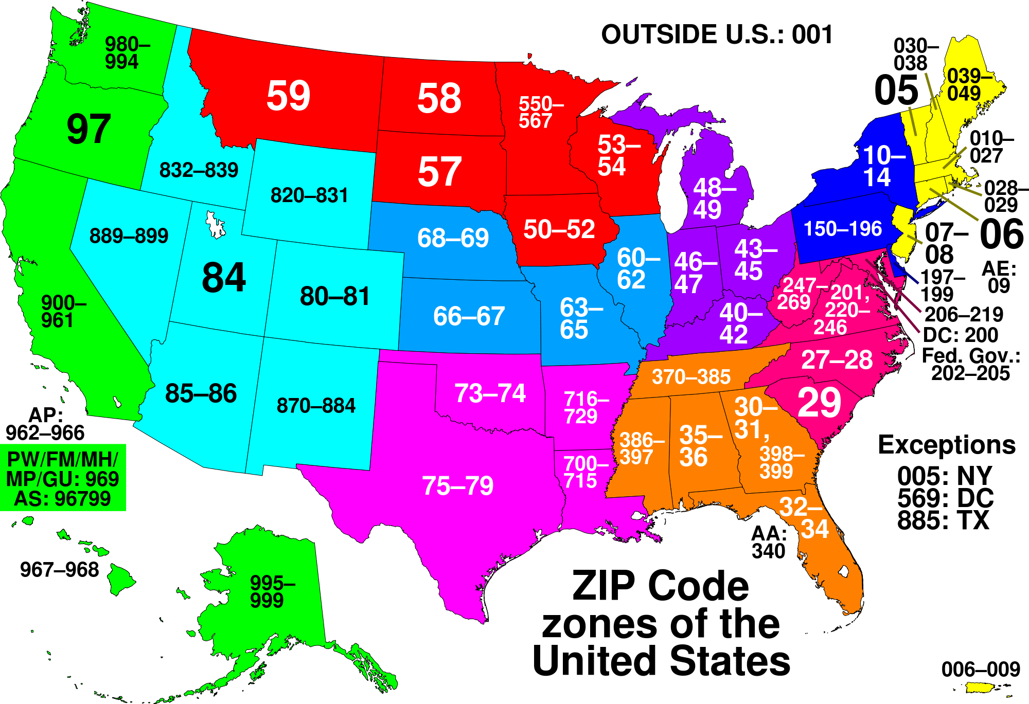
The ZIP Code system is a cornerstone of the USPS's mail processing infrastructure. Each ZIP Code corresponds to a specific geographic area, ranging from a single building to an entire city or region. The first digit of a ZIP Code represents a broad geographic region of the United States, while the subsequent digits narrow down the location to more specific areas. For example, ZIP Codes beginning with "1" typically correspond to the northeastern United States, while those starting with "9" are associated with the western states.
#Infobox
#Overview
The ZIP Code system is a cornerstone of the USPS's mail processing infrastructure. Each ZIP Code corresponds to a specific geographic area, ranging from a single building to an entire city or region. The first digit of a ZIP Code represents a broad geographic region of the United States, while the subsequent digits narrow down the location to more specific areas. For example, ZIP Codes beginning with "1" typically correspond to the northeastern United States, while those starting with "9" are associated with the western states.
The basic five-digit ZIP Code is sufficient for most mail delivery purposes. However, the ZIP+4 system, introduced in 1983, adds an additional four digits to provide even greater precision. These extra digits can refer to a specific block, building, or even a floor within a building, further streamlining the delivery process.
#History / Background
#Origins
The ZIP Code system was developed in response to the growing volume of mail in the United States during the mid-20th century. Before its introduction, mail delivery relied on a patchwork of local postal codes and manual sorting methods, which were increasingly inefficient as mail volume surged. The USPS recognized the need for a standardized, automated system to improve delivery speed and accuracy.
In 1962, the USPS proposed the Zone Improvement Plan, which aimed to divide the country into zones based on geographic regions. The plan was approved, and the first ZIP Codes were introduced on July 1, 1963. The initial system used five-digit codes to represent broad geographic areas, with the first digit indicating a major region of the country and the following digits narrowing down to specific zones.
#Expansion and Modernization
In 1983, the USPS introduced the ZIP+4 system to further refine the delivery process. This expansion added four additional digits to the original five-digit code, allowing for more precise location identification. The ZIP+4 system is particularly useful for businesses and high-volume mailers who require greater accuracy in delivery.
Over the years, the ZIP Code system has evolved to incorporate technological advancements. Automated mail sorting machines now use optical character recognition (OCR) to read ZIP Codes and route mail more efficiently. Additionally, the USPS has integrated ZIP Codes into its Intelligent Mail Barcode (IMb) system, which combines routing and tracking information into a single barcode.
#How It Works
#Structure of a ZIP Code
A standard ZIP Code consists of five digits, each serving a specific purpose in identifying a geographic location. The structure is as follows:
- First Digit: Represents a broad geographic region of the United States. For example, "0" through "5" correspond to the northeastern states, while "9" represents the western states.
- Second and Third Digits: Narrow down the location to a specific sectional center facility (SCF) or a major metropolitan area.
- Fourth and Fifth Digits: Further refine the location to a specific post office, a group of streets, or a large building.
The ZIP+4 system adds four additional digits to the basic five-digit code, providing even greater precision. These extra digits can refer to a specific block, building, or even a floor within a building.
#ZIP Code vs. Postal Code
While the terms "ZIP Code" and "postal code" are often used interchangeably, they refer to different systems. A ZIP Code is specific to the United States and its territories, whereas a postal code is a general term used in many countries to describe a system of codes for sorting and delivering mail. For example, Canada uses a six-character postal code system, while the United Kingdom employs a system of outward and inward codes.
#Important Facts
- Geographic Coverage: ZIP Codes cover the entire United States, including its territories such as Puerto Rico, Guam, and the U.S. Virgin Islands.
- Special ZIP Codes: Some ZIP Codes are reserved for special purposes, such as military mail (APO/FPO/DPO addresses) or diplomatic mail.
- ZIP Code Tabulation Areas (ZCTAs): The U.S. Census Bureau uses ZIP Code data to create ZCTAs, which are statistical geographic areas that approximate the delivery areas of USPS ZIP Codes.
- ZIP Code Boundaries: ZIP Code boundaries do not always align with city or county lines. They are designed to optimize mail delivery rather than reflect political boundaries.
- ZIP Code Changes: ZIP Codes can change over time due to population shifts, new developments, or reorganizations by the USPS. Businesses and residents are notified of changes in advance.
#Timeline
- ZIP Codes are introduced
ZIP Codes are introduced by the USPS on July 1.
- Mandatory use of ZIP
Mandatory use of ZIP Codes for bulk mailers begins.
- ZIP+4 system is introduced
ZIP+4 system is introduced to provide greater precision in mail delivery.
- The USPS introduces the
The USPS introduces the *Intelligent Mail Barcode (IMb)* system, which integrates ZIP Codes with tracking information.
- Automated mail sorting machine
Automated mail sorting machines become more advanced, relying heavily on ZIP Codes for routing.
- The USPS introduces *Informed
The USPS introduces *Informed Delivery*, a service that allows customers to preview incoming mail using ZIP Code data.
#Related Terms
#FAQ
What does What Is A ZIP Code? cover?
Explains what a ZIP code is, how it works, common examples, and why the concept matters for readers.
Why is What Is A ZIP Code? important?
It helps readers understand key concepts, compare practical use cases, and evaluate how Development decisions affect outcomes, risks, and implementation choices.
What should readers verify before applying this topic?
Readers should compare the benefits, limitations, data requirements, and related themes such as Explainer, Zip, Code before using the ideas in real projects.
#References
- What Is A ZIP Code? terminology and background research
- What Is A ZIP Code? use cases, implementation examples, and limitations
- Development best practices, standards, and risk guidance
- Explainer case studies, benchmarks, and current industry analysis



Comments
No comments yet. Start the discussion with a useful note.